GIS Approach to Assess Walkability in Bangalore City (M.Sc. Thesis, 2017)
Overview
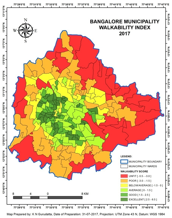
This project developed a Walkability Index for Bangalore using GIS-based spatial analysis. It combined population density, land-use diversity, street connectivity, and destination proximity to objectively assess walkability across all municipal wards in ArcGIS. The work produced an evidence-based framework for identifying pedestrian barriers, planning priorities, and urban mobility opportunities in the 2017 context.
Study Area: Bangalore City, India
Duration: 2017
Role: M.Sc. Thesis Research
Status: Completed
''' '''
'''
Methods & Tools
Data Sources
- Publicly available spatial and demographic datasets for Bangalore
- Ward-level administrative boundaries
- Land-use, street network, and destination datasets compiled from multiple public sources
Processing Steps
- Collected and integrated multi-source public datasets.
- Standardized spatial layers and normalized built environment indicators.
- Modeled walkability using population density, land-use diversity, street connectivity, and destination proximity.
- Evaluated ward-level patterns to identify barriers and opportunities for pedestrian-friendly planning.
Tools Used
| Tool | Purpose |
|---|---|
| ArcGIS | Spatial analysis and index construction |
| GIS data processing workflows | Data integration and normalization |
| Statistical / geospatial modeling | Indicator scoring and comparison across wards |
Key Findings
- Generated a ward-level Walkability Index for Bangalore using objective spatial indicators.
- Identified neighborhoods with stronger pedestrian-supportive urban form and areas with structural walkability deficits.
- Demonstrated a replicable GIS framework that can be adapted for other Indian cities.
- Supported pedestrian-friendly planning and urban mobility assessment in the 2017 context.
Impact
The thesis provided evidence-based recommendations for improving urban walkability and pedestrian planning in Bangalore. It also established a reusable analytic template for evaluating walkability in other Indian cities. Since 2017, urban transformation and policy shifts may have altered local walkability conditions, so the findings should be read as a historical baseline rather than a current assessment.